Chapter 1 - GNSS Overview
“New ideas pass through three periods: 1) It can't be done. 2) It probably can be done, but it's not worth doing. 3) I knew it was a good idea all along!” Arthur C. Clarke, British author, inventor and futurist.
Most of us now know that GNSS "was a good idea all along" and that we are now well into the third phase.
The basic concepts of satellite positioning are very easy to understand. They are so straightforward, in fact, that one of our employees was asked by his daughter to explain it to her grade 4 class.
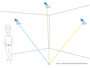
Before the class started, he set up the following demonstration, his version of “string theory.” He tacked cardboard figures of three satellites to the walls and ceiling of the classroom, as shown in Figure 1. Each “satellite” had a length of string stapled to it. He marked a location on the floor with a movable dot, then drew the strings down and marked where they all reached the dot. The strings now represented the distances from the dot to the individual satellites. He recorded the location of the dot and removed it from the floor.
When the students came into the classroom, our employee had them use the strings to determine the location. To do this, the students drew the strings down until the ends of the strings came together at one point on the floor. They marked this point with a movable dot and compared it with the previously marked position. They were very close. This simple demonstration showed that, if you know the location of three satellites and your distance from them, you can determine your position.
The determination of position is made quite a bit more complicated by several factors—the satellites are moving, the signals from the satellites are very weak by the time they reach the earth, the atmosphere interferes with the transmission of radio signals and, for cost reasons, the user equipment is not as sophisticated as the equipment in the satellites.
“The more you explain it, the more I don't understand it.” Mark Twain, American author and humorist.
We agree. We will provide a more detailed explanation of position determination in Chapter 2.

