Galileo

“Measure what is measurable, and make measurable what is not so.” Galilei Galileo, Italian physicist, mathematician, astronomer, and philosopher.
In May 1999, a mountaineering expedition carried a GPS receiver to the summit of Mount Everest, allowing them to accurately measure its elevation at 8,850 m (29,035 ft). We think Galileo would have been happy.
Galileo, Europe’s planned global navigation satellite system, will provide a highly accurate and guaranteed global positioning service under civilian control. The United States and European Union have been cooperating since 2004 to ensure that GPS and Galileo are compatible and interoperable at the user level.
By offering dual-frequencies as standard, Galileo will deliver real-time positioning accuracy down to the metre range, previously not achievable by a publicly available system.
Galileo will guarantee availability of service under all but the most extreme circumstances and it will inform users, within seconds, of a failure of any satellite. This makes it suitable for applications where safety is crucial, such as in air and ground transportation.
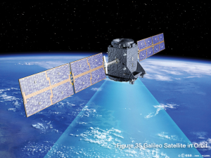
The first experimental Galileo satellite, part of the Galileo System Test Bed (GSTB) was launched in December 2005. The purpose of this experimental satellite was to characterize critical Galileo technologies, which were already in development under European Space Agency (ESA) contracts. Four operational satellites were launched, two in October 2011 and two in October 2012, to validate the basic Galileo space and ground segment. In coming years, the remaining satellites will be launched, with plans to reach FOC likely sometime after 2020.
System Design
The Galileo space segment is summarized in Table 9. Once the constellation is operational, Galileo navigation signals will provide coverage at all latitudes. The large number of satellites, together with the optimization of the constellation and the availability of the three active spare satellites, will ensure that the loss of one satellite has no discernible effect on the user segment.
Galileo will provide a global Search and Rescue (SAR) function, based on the operational search and rescue satellite-aided Cospas-Sarsat2 system. To do this, each Galileo satellite will be equipped with a transponder that will transfer distress signals to the Rescue Coordination Centre (RCC), which will then initiate the rescue operation. At the same time, the system will provide a signal to the user, informing them that their situation has been detected and that help is underway. This latter feature is new and is considered a major upgrade over existing systems, which do not provide feedback to the user.
Table 9: Galileo Satellite Constellation
| Satellites | 27 operational and three active spares |
| Orbital planes | 3 |
| Orbital inclination | 56 degrees |
| Orbit radius | 23,222 km |
Galileo Signals
Table 10 provides further information about Galileo signals.
Table 10: Galileo Signal Characteristics
| Designation | Frequency | Description |
| E1A | 1575.42 MHz | Public regulated service signal. |
| E1B | 1575.42 MHz | Safety-of-Life and open service signal (data). |
| E1C | 1575.42 MHz | Safety-of-Life and open service signal (dataless). |
| E5a I | 1176.45 MHz | Open service signal (data). |
| E5a Q | 1176.45 MHz | Open service signal (dataless). |
| E5b I | 1207.14 MHz | Safety-of-Life and open service signal (data). |
| E5b Q | 1207.14 MHz | Safety-of-Life and open service signal (dataless). |
| AltBOC | 1191.795 MHz | Combined E5a/E5b signal. |
| E6 A | 1278.75 MHz | Public regulated service signal. |
| E6 B | 1278.75 MHz | Commercial service signal (data). |
| E6 C | 1278.75 MHz | Commercial service signal (dataless). |
Galileo Services
Five Galileo services are proposed, as summarized in Table 11.
Table 11: Galileo Services
| Service | Description |
| Free Open Service (OS) | Provides positioning, navigation and precise timing service. It will be available for use by any person with a Galileo receiver. No authorization will be required to access this service. |
| Highly reliable Commercial Service (CS) | Service providers can provide added-value services, for which they can charge the end customer. The CS signal will provide high data throughput and accurate authenticated data relating to these additional commercial services. |
| Safety-of-Life Service (SOL) | Improves on the Open Service by providing timely warnings to users when it fails to meet certain margins of accuracy. A service guarantee will likely be provided for this service. |
| Government encrypted Public Regulated Service (PRS) | Highly encrypted restricted-access service offered to government agencies that require a high availability navigation signal. |